Details: Spring Creek Pass East to Snow Mesa 
Distance: 6.4 - 10.0 miles (round trip)
Rio Grande National Forest, near Lake City in Southwest Colorado
Hike Facts
- Distance: 6.4 - 10.0 miles (round trip)
- Elevation: 10,898-ft. - 12,380-ft.
- Elevation Gain: 1,482-ft.
- Difficulty: moderate-strenuous
- Trail Highlights: See Trail Intro
- Basecamp(s): Lake City
- Region: Southwest Colorado

Hikers ascending from Spring Creek Pass to the beautiful, tundra-clad plateau of Snow Mesa are rewarded with glorious views of the San Juan Mountains to the west/southwest of the Lake City area. Extend the hike by climbing Baldy Cinco or walking to the ponds at the east end of the mesa.
Spring Creek Pass East to Snow Mesa

The combined Continental Divide/Colorado Trails to Snow Mesa begin at Spring Creek Pass on Highway 149. (See driving directions below.) The path immediately starts ascending on moderately-steep grades through forest, marred by trees killed by the beetle infestation. Openings in the trees offer fine views of the San Juan Range rising to the west.
At 1.0 mile the grade abates as the trail breaks from the trees and crosses a meadow, passing a large rock cairn along the way. From the meadow enjoy great views west to the high peaks towering above the Lake Fork of the Gunnison, including Red Mountain, Grassy Mountain, Sunshine Peak and Redcloud Peak. The Rio Grande Pyramid rises to the southwest while Uncompahgre, the Wetterhorn and the Matterhorn grace the skyline to the northwest. Ahead views open to the talus-clad slopes beneath Snow Mesa.
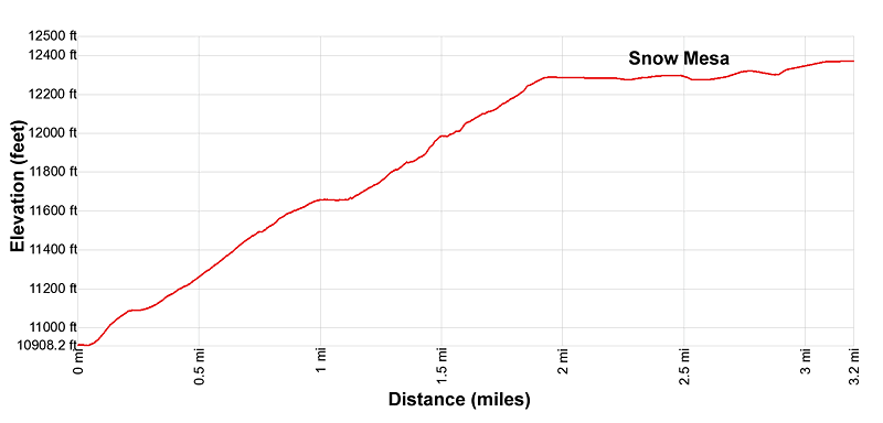
Soon the trail reenters the trees and the climb resumes on moderately steep grades. At 1.4 miles the trail emerges from the trees into rocky meadows, ascending along the north side of the East Spring Creek drainage. The meadows soon give way to talus slopes as the trail swings to the northeast, reaching the western rim of Snow Mesa (12,270-ft.) at 1.9 miles.
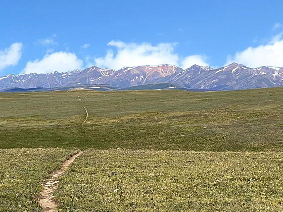
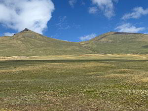
Upon arriving atop the mesa take time to enjoy the panoramic views of the 13,000-14,000-ft. peaks of the San Juan Range to the west. Snow Mesa, the largest expanse of tundra in the lower 48 states, stretches as far as the eye can see to the east. Baldy No Es Cinco and Baldy Cinco, along with 3 nearby summits, rise above the tundra to the northeast. (Baldy No Es Cinco is the pointy peak to the west of Baldy Cinco.)
The trail now travels east across the tundra on gentle grades. Large rock cairns and brown stakes help keep you on track if snow covers a portion of the trail. Progress will be slow as you stop often to admire the stunning views to the west.
At 3.2 miles reach a high point (12,380-ft.) on the mesa to the south of Baldy Cinco. This point is a short distance beyond one of the large rock cairns. To the east the trail dips into and then climbs out of a broad gully. This is a good turn around point, resulting in a 6.4 mile round-trip hike. On the return leg of the hike the fabulous views are now front and center as you retrace your steps across the tundra and then drop down through the trees to the trailhead.
Parties looking for a longer hike can continue heading east across the mesa, which now descends gently to a group of ponds near the eastern edge of the mesa at 5.0 miles. Along the way the trail crosses two gullies. During the height of the summer the moist tundra around the ponds supports beautiful displays of wildflowers. Totally round-trip distance to the ponds is 10.0 miles with a 1,700-ft. elevation gain.
Alternatively, hikers with time, energy and favorable weather can extend the hike by climbing Baldy Cinco and Baldy No Es Cinco. From the turn-around point return to the last large rock cairn and then start hiking north up the south ridge of Baldy Cinco. As you climb you should see a large rock cairn on the ridge. Aim for this point at approximately 13,080-ft. and then climb to rounded summit of Baldy Cinco (13,383-ft.). Distance from the trail to the summit is approximately 1.5 miles, depending on your route.
Baldy Cinco enjoys jaw-dropping views of the San Juan Mountains. From this vantage point you can now see Lake San Cristobal and the high peaks in the Weminuche Wilderness. San Luis Peak (14,014) and the summit of Stewart Peak (13,983) rise to the east.
From Baldy Cinco it is relatively easy to bag Baldy No Es Cinco. Start by descending the talus slope along Baldy Cinco’s western slopes to a saddle at 12,900-ft and then climb to the rocky summit of Baldy No Es Cinco (13,313-ft.). Total distance is about 0.9 miles. Near the top of the ascent you are treated to dramatic views of the peak’s sheer north wall. Atop the summit is a very tall rock cairn and more fabulous views.
After you are done taking in the views descend Baldy No Es Cinco’s southern slopes, initially through a talus field and then tundra clad meadows, to the CDT/CT. Turn right and return to the Spring Creek Pass trailhead in 4.2 miles. Total distance for hiking Baldy Cinco and No Es Cinco is about 9.8 miles with 2,900-ft. of elevation gain.
Elevation Profile

Buy the BookThis opinionated guide includes all the hikes in the Ouray, Telluride, Silverton and Lake City sections of the website plus info on local services and nearby attractions. | |
Driving Directions
Driving Directions from Lake City: From the Lake City Tourist Information Center, at the junction of Gunnison Avenue (Main Street) and Gunnison Street, follow Colorado 149 South for 17.7 miles to Spring Creek Pass. Turn right into the Spring Creek Pass Campground. The day use parking area is located on the right side of the spur road before you reach the loop for the camping area. The campground includes an outhouse. From the parking area, carefully cross Highway 149. On the east side of the highway is the Continental Divide/Colorado trailhead to Snow Mesa and San Luis Pass.
Trail Resources
Trail Intro / Trail Photo Gallery / Trail Map
Basecamp(s) Information:
Lake City
Region Information:
Southwest Colorado
Other Hiking Regions in:
Colorado
